“It ain’t over ’til it’s over” ~Yogi Berra 

I guess I was right. I attended the January 15th meeting of the Community Services Commission meeting where the “Final” 75th and 76th Streetscape Schematic Design” was presented by the H.R. Green Consultants to the commission members for action. The only thing was that Jonathan Vlaming, the Planning Manager for the Three Rivers Park District was there as well and informed the Community Services Commission that the Three Rivers Park District prefers one 10 foot wide trail on the boulevard instead of bike paths on 75th Street. It appears the Three Rivers Park District is concerned that a 8′ trail is not wide enough to accommodate all the  walkers, rollerbladers, and children on bikes that want to use the side path. So the on street bike paths will have to go to make room for a wider side path and evidently the commuting bikers and adult recreational bikers will have to join the above mentioned on the side path. He also made a case that bike paths were not nesassary according due to the amount of traffic on the road. He held up a print out of the “MnDOT Bicycle Bikeway Facility Design” to emphasise the states guildlines. I am glad to know someone is reading my blog.

Fun with Graphics

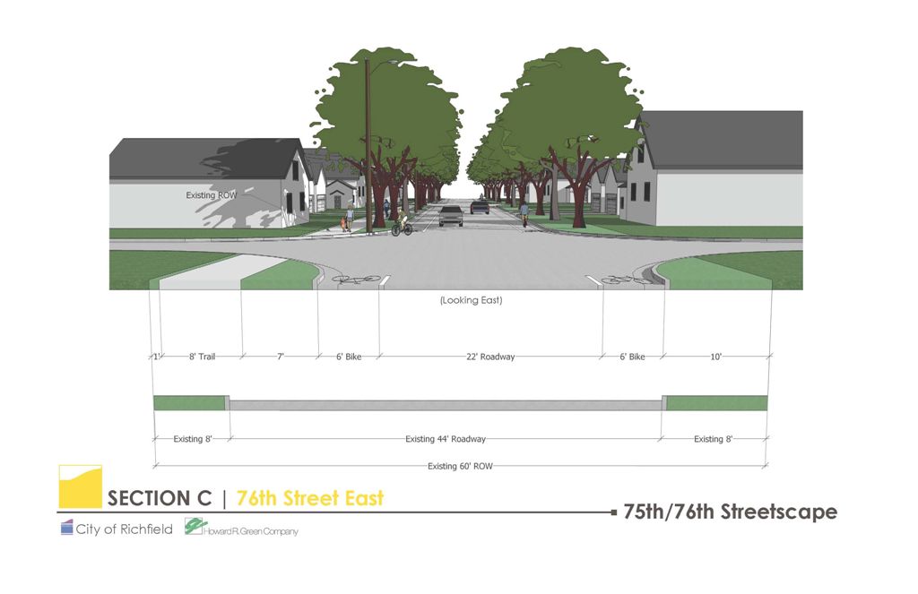
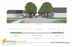
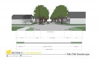
The strangest part, there were the drawings presented by H. R. Green Consultants. There were three different alternatives. First, alternative “A” which had no bike paths and a 10′ foot side path, which appeared to the be clear favorite of H. R. Green Consulting and the Three Rivers Park District, next was alternative “B” which was approved of by the Transportation Commission and presented at the January 10th City Hall meeting to the public and has an 22′ roadway, two 6′ bike paths and one 8′ side path, and alternative “C” which has an 18′ roadway, two 5′ bike paths and one 8′ side path. What struck me was the actual graphic that was presented. Alternative “C” was the very same graphic as Alternative “B” but it marked that the north boulevard was 12′ instead of the 6′ boulevard in  “B”. To me the graphic was very misleading since it gave the impression that the skimpy boulevard left no room to add on to the side path. However, 12′ is a very generous boulevard, that could hold its own even on Summit Avenue and that was not reflected in the graphic.   

75th Street Alternative B

Alternate A 

75th Street Alternative A

Alternate B

75_alt_c2.jpg

Alternate C with measurements outlined

It occurred to me that you could reduce the boulevard to 10′ (still a mighty boulevard by any measure) and increase the side path to 10′ and everybody should be happy. However, again it appeared to me that H. R. Green and the Three Rivers Park District were not exactly keen on it. One of there big objections to the bike paths is their perceived need for “Green Space” As a gardener that has created several community gardens I am a sucker for green space. However, I can’t help resent that they were framing it as an argument as a bike paths vs. green space. I can understand parking lot vs. green space, shopping mall vs. green space or eight lane highway super highway vs. green space but bike paths?! The irony is that much of the bike path goes  a long the open fields of a school and of Donaldson Park. Is there really a lack of green space there?

The Science of Graphics

Also interesting are the  “charts” H. R. Green Consulting came up with. They are a spreadsheet showing how all their subjective design criteria in an official and professional looking format that supports their original plans of no bikeways on 75th and no south sidewalk east of Nicollet Avenue. The irony is that they said that they did not have the time to correct the graphic in alternative “C” for the meeting but they did have time to create these. 

 75th Street Chart 76_chart2.jpg

So what was the Result of the Meeting?

 The Community Services Commission  was interested in parking along Donaldson park, the also liked alternate design “C” with with the change of widening the side path from 8′ to 10′.  They were also interested in keeping the sidewalk on the south side of 76th Street east of Nicollet, but keeping it only 4′ vs 6′ wide. The only trouble with that is the city’s current equipment can only go down 6′ paths, the 4′ would be inaccessible to plow during the winter. However, it appeared not to be a problem that was insurmountable.  As far as what’s next, its a bit unclear to me. It will go in front of the Transportation Committee again as well as the city council, but I am unsure about if  there be another public meeting addressing any changes.    

75th Street with bike lanesJanuary 10th at Richfield city hall, was the presentation of preferred alternative. That is, bike lanes on BOTH 76th and 75th and sidewalks on both sides on 76th following the complete span from 35W to Cedar Avenue. So needless to say I was doing the happy dance. At the January 2nd Transportation Commission Meeting, they voted to go with recommending to the city council the alternative, adding in the bike lanes and extending the sidewalk from Nicollet to Cedar. The presentation itself was interesting. I was the first time I saw representatives from the Metropolitan Council as well as the The Three Rivers Park District. Both were on hand to talk about the different aspects of the project, the Metropolitan Council talked about ever-not-so-sexy but important sewer project and the Three Rivers Park District talked about and answered questions about the trail. The one thing of interest was other than the great news about the path improvements was that there looks like there are no plans for boulevard trees due to the narrowness of the boulevard… that has me confused and I find it hard to believe, I have lived in Minneapolis and anyone from there can tell you how Minneapolis can grow mighty trees on slivers of boulevards half the size of what is proposed. richfield_76th_east_11152007.jpgSo all this does give the impression that the planning part it close to completion, however that would be an error. There is still at least three more meetings and one being with the Community Services Commission. The plan also has to get voted on by the city council before Pinocchio can become a real boy.

Lyndale Bridge over I-494, looking south toward Bloomington - showing hazardous sidewalk conditions.It’s coming, I look forward to it with both hope and dread. The current bridge is not only pedestrian and bike unfriendly to say the least (I think the 1 foot sidewalks were only designed as a place for trash in the summer and plowed snow in the winter and never were intended for human feet) but it is waaay inadequate to handle the traffic on it now. Besides all that, the bridge is butt ugly, it is rundown and built with all the soulless charm and creativity of an Eisenhower/Johnson era highway project.The current design calls for a Penn Avenue style interchange. Not really a quaint covered bridge design that would go with the “small town” image that many in Richfield try to convey to the rest of the world. However, it will be a traffic mover which is what is need for the area.

Lyndale Bridge over I-494, looking north toward Richifield - showing hazardous sidewalk conditions.However, it is the bridge’s aesthetics that worry me the most. If anyone has gone over the Penn Avenue Bridge, it becomes quite obvious while it has the sidewalks that the Lyndale Bridge lacks it is large desolate span of concrete in an “Eisenhower/Johnson era” design. This is troubling because Lyndale is a major gateway into Richfield, and a bridge with all the flare of a Soviet five year plan project doesn’t speak well of Richfield. Sadly there has been a tread that Richfield has appeared to have missed completely by other communities, such as St. Louis Park, Woodbury, Minneapolis, St. Paul etc…. to sex up and humanize their bridges with decorative lighting, railings and formed concrete mimicking stone. This of course costs money which some frugal non-fussy Richfield residents are loathe to part with. Sadly, if the Penn Avenue bridge is setting the stage for the rest of the 494 expansion and redesign, it will keep it concrete river look and feel.My guess is that aesthetic design while not a requirement in civic projects, it makes the difference between swilling with pride in your pig pen or swelling with pride in your community.

The meeting December 18th, where H.R. Green Consulting presented their recommendation to the Community Services and Planning Commissions was disappointing. There was quite a bit of discussion directed toward bike paths and sidewalks. Unfortunately, much of that discussion was instigated by me. The Community Services and Planning Commissions’ interests appeared to be mostly directed at just how much parking to give cars along the trails. It appeared to me that they were happy with the minimal consideration given to walkways and on-street bike paths.
A trail is more than just a trail. Just like a freeway is more than just a freeway. It is economic development. Bikes ways and trail ways also have economic impact on the development (or redevelopment) in the case of Richfield). With Minneapolis, the number two biking city in the nation to the north of us, it is unwise not to embrace a bike culture to attract young professionals.
The short-sited self-involved commentary by community members attending meetings fails to understand it is not just about what they want, but what will attract young professionals to the neighborhood. 
Those that think we can use our “suburban charms” will find the attractions of the new “suburban” development that once in enticed young couples in the 40’s and 50’s to move here, have long disappeared and we can not compete with younger sexier newer suburban developments further out. We need to create that new model for ourselves based more on Minneapolis than Lakeville.

So back to writing about the developments on 76th/Pleasant and 76th/Lyndale. It will be interesting what the developers will have to offer as far as “Green Housing” practices, that is what are the materials the development is made of, what kind of energy conservation and usage does it have, etc… Some can add on to the cost of the development, but can the developers or the city get grants to defray the costs? One developer did mention it during the community meeting but unfortunately it was quickly passed over.

December 18th at the Richfield Community Center. This is a combined meeting with H.R. Green Consulting presenting to BOTH the Community Services Commission and the Planning Commission. If this is like the last meeting with the Transportation Commission expect this to be lightly attended. If only they could make community meetings more interesting than “Pimp my Ride” and “American Idol” we might get people to attend…

Bikeway Facility Design ManualA couple of interesting PDFs on the Technical Guidance for Bikeways put out by Mn/DOT
Mn/DOT Bikeways Facility Design Manual

MnDOT Bicycle Modal Plan

From MnDOT Bicycle Modal Plan

3-2.0
Shared use paths, greenways, and state trails must be designed for users other than bicyclists. The design should take into account others on shared use paths such as inline skaters, adult tricycles, bicycle trailers, recumbent bicyclists, and wheelchair users. The dimensions and operational characteristics of bicyclists are important, other user types that are allowed to share the same space as bicyclists should be integrated into the initial planning stages and the design and selection of a bikeway type.

4-2.1 Consideration of Geometric and Operation Factors
Intersections and Driveways

Intersections and driveways are roadway features that require extra consideration and care as they relate to bikeways, and provide opportunities as well as potential difficulties for designers of bikeways. Since bicyclists generally want to reach the same destinations as motorists, these features provide access to those destinations. They also present potential locations for conflicts between motor vehicles and bicycles. Most bicycle crashes with motor vehicles occur at
intersections.

4-3.3 Standard Bicycle Lanes
A bicycle lane is a portion of a roadway designated by striping, signing, and pavement markings for the preferential or exclusive use of bicycles. These one-way bicycle facilities are appropriate for roads with an urban (curb and gutter) cross section. Bicycle lanes carry bicycle traffic in the same direction as adjacent motor vehicle traffic.

I was also shocked to hear H. R. Green Consulting tell the Transportation Commission that people who lived on 75th Street were concerned about not having parking and that they intend to make space for parking  with bump-ins along 75th Street. I was at that November 28th meeting and only one woman voiced her concern. There was another resident who lived on 75th that said he thought the trail and bike paths were good ideas and that not having on street parking was not a large problem on his street due to everyone having driveways. He also said that he had discussed this with several neighbors and they liked the trail nor had issues with the parking. That testimony they curiously left out by H. R. Green Consulting at the commission meeting.

This was an interesting meeting. Well, actually it was as fun as watching paint dry. But it was informative. H.R. Green Consulting made a presentation to the Transportation Commission. It pretty much confirmed my fears. No on street bike path, but not only that, it appears that the sidewalk is the “trail” a “multi-use” trail for walkers, joggers, skateboarders, rollerbladers, baby strollers, wheel chairs and biking since it is not provided on the street.

Calling it a city sidewalk a trail is a bit like calling I-35E a parkway. oh, wait… it is called it a parkway.

H.R. Green Consulting holds the view that 75th Street is too narrow to have bike lanes and that since the mission of the Three Rivers Park District (formerly Hennepin Parks), which is behind this trail, is to create a multi-use trail AND because there has to be a street for cars – the bike paths have got to go.

First problem – the “Trail” (sidewalk)

The problem with that is the belief that sidewalks are safer than streets for biking. Bicycle side paths such as the one on 75th have proved so dangerous that even the US government instructs that they be used in only the few locations where their dangers are insignificant. The problem is not just pedestrians; urban sidepaths cause difficult and dangerous car-bike conflicts at every driveway and intersection. How so?

A car backing down a driveway will slow down at street level before entering expecting fast moving vehicles. This is not the case for a sidewalk. Not seeing pedestrians the car will back out past the sidewalk to the street .

A car is more likely to see a bicyclist in the street when making a right hand turn but is less likely to see the bicyclist up on the sidewalk entering in to the street when making the turn.

Sidewalks which have been later re-designated as cycle paths may contain various obstructions including bus stops, pillar boxes, telecommunications cabinets and pedestrians.

Cycle paths are generally less frequently cleaned of debris and snow/ice than roads.

Contrary to intuition, cyclists riding on bicycle paths (now called “shared use paths”) have a higher crash rate than cyclists riding on roads, although not as high a crash rate as cyclists riding on sidewalks (Aultman-Hall and Kaltenecker 1998). The risk of injuries on paths compared to roads has been calculated as 40%, 80%, and 260% higher (Moritz 1998, Aultman-Hall and Kaltenecker 1998, Kaplan 1976). Some of the increased risk may be explained by the greater likelihood of inexperienced cyclists to use paths or sidewalks (Aultman-Hall and Adams 1998). However, the studies of bicycle club members, who are much more experienced than average cyclists, reveal a higher crash rate on paths even for these riders.

Second problem – 75th Street with no bike lanes

Bike lanes usually makes both cyclists and motorists feel more comfortable, and, by allowing motorists to pass with less delay at a greater distance, may reduce bad feelings on both sides.

Bike lane stripes serves the same engineering purpose as any other lane stripe, and should be employed under similar circumstances–to delineate travel paths that could otherwise be ambiguous, providing for more predictable movement.

Bike lane stripes may also provide better protection against hijacking roadway space by re-striping it for additional traffic lanes.

Bike lane strips remind motorists that bicycles belong on the road, and to expect them there.

So what to do….

California Highway Design ManualTake a page from the California Highway Design Manual – CHAPTER 1000
BIKEWAY PLANNING AND DESIGN

H.R. Green Consulting says that there just is no room for an on-street bike path. There is 60 feet available to work with. H.R. Green Consulting wants the city to create a 26′ road leaving 14′ on north side and 10′ on the south for boulevards and Trail. 10′ of the boulevard on the north side would be made into a trail leaving the boulevard at 14′. So that is a 14′ and 10′ boulevard, amazingly generous by any standard, and given that the south side does not have a sidewalk, its just green space (city property) adjacent to the home owners property. No sidewalks, no nothing.

However, lets say we want to go crazy and add say two bike lanes. One going east and one going west. Crazy. They are proposing 6′ bike lanes on 76th Street. The California Highway Design Manual calls for a 5′ bike lane minimum with curb. So lets say we want to be stingy and go with two 5′ bike lanes times 5′ equals 10′ we subtract that from the boulevard equally leaving 9′ and 5′ boulevards. Still a nice chunk of city boulevard space.

75th StreetNow did I mention that the road surface without bike lanes is 22′ on 76th Street?
So the road surface on 75th Street as planned is 26′ and if we do another crazy thing like reduce it to… say… 22′ that gives us 4′ to give back to the boulevards. Split equally again the boulevard are now 11′ and 7′ – amazing.

Again, if we take a page out of the California Highway Design Manual we could even squeeze an extra foot of usable space for the bike lanes by blending street with the curb.
So in the end we have from north to south:

Trail 10′ | Boulevard 11′ | Bike Lane 5′ | Roadway 22′ | Bike Lane 5′ | Boulevard 7′ = 60′ total

Why couldn’t H.R. Green Consulting do the math? …and hell I’m not even getting paid.

76th between Nicollet and CedarAt the November 28th meeting, in addition to showing bike path placement they also showed sidewalk placement. In a city of empty nesters that strongly oppose sidewalks, some because they do not have kids and don’t care if someone else’s kids have to use the street to get around, or others, because they hold on to an antiquated notion that no sidewalks = suburban living at its finest and only poor people walk (they do not know there is a tread in new suburban communities for sidewalks by young couples), I suppose I should be grateful for the pitiful few sidewalks proposed the the street scape plans. However the most egregious proposal of them is to only put sidewalks on one side (the north) of 76th street from Nicollet to Cedar. The statement by H.R. Green Consulting was that it wasn’t needed and that the neighbors there “valued” green space. I disagree, the value of the sidewalk – and green space, is in the whole of the 76th street project not just one section.

It would be insane to let the individual property owners decide whether they want a sidewalk in front of their property or “green space”, you would have the sidewalk starting and stopping making it worthless. In a sense that is what is happening here. They are devaluing the asset of the sidewalk by cutting it short to placate one or two people in the east section.

Privatizing of Public Space
The other problem I have with this is the give-away of public land. The road is being narrowed and the land is being handed over to private property owners. Yes the city will still own the land, which also means they will not be tax assessed for it as well. What a deal! The Richfield walkers and kids loose out and some complainers get tax free land.

If the city wants to make it fair, the city should bring back an option it dropped early on, it should move the green space to a center median which keeps it public (and I think looks very sexy). They could then move the road closer to the houses since sidewalks are not valued there.

The real story – Sidewalks are needed
If you ever have walked or biked that area, like I have, you will see that there is a real need for sidewalks on both sides of the street between Nicollet and Cedar even for so than between 35W and Nicollet. There are two major parks many kids walk and bike to, (Washington and Roosevelt) and two churches (Assumption and House of Prayer Lutheran Church) along that south section. I think H.R. Green Consulting’s assessment that a sidewalk isn’t necessary on the south side is incorrect and would be very sad for the community if that comes to pass.

« Previous PageNext Page »